The government is growing their support for School Streets and the need for safer routes is becoming more critical. Alongside the Marston Holdings Group, Project Centre attended and exhibited at the latest Landor Links School Streets Conferences in London first and then in Bradford.
The event was packed with professionals from a wide range of organisations. This included Active Travel England, combined authorities and community organisations. Panellists discussed key topics such as:
- Consultation and engagement
- Data and monitoring
- Infrastructure design
- Traffic management and enforcement
- Funding for School Streets
Our key takeaways
Engaging the community
At the London School Streets Conference, Islington Council shared their experience around engaging the community after the measures’ implementation. The Council explained how they found that people weren’t happy with that strategy as they didn’t feel included in the decision making process.
School Streets measures include restrictions in place at school drop off and pick up times. Communities can deem these as limitating if you don’t tell them the full story first.
Why do we need School Streets?

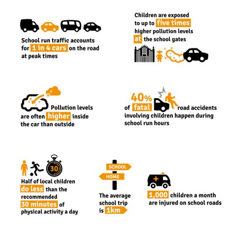
The current statistics for pollution and road safety around school streets are alarming. Apart from increasing the risks of road collisions, higher levels of motor vehicle traffic can significantly increase pollution. Hence this affects the community’s health and wellbeing. Researchers found that children exposed to harmful levels of pollution have a reduced lung capacity compared to the national average. School Streets need to be implemented to protect children and families across the country.
Including everyone’s lived experience can help designers, engineers and local authorities to gather evidence on what is currently working well, what needs to be changed, and how. Our Head of Communications and Engagement, Steph Bortoli, and our Associate, Nina Mehmi, were at the School Streets Conference in Bradford, discussing how to build a bridge between the communities’ evidence base and the actual environmental data.
Utilising data
Air quality monitoring, Geographical Information Systems and computer-generated designs are all powerful tools to help local authorities, communities and stakeholders visualise the current situation as well as provide them with the opportunity to explore sites after planned interventions.
Data and monitoring can facilitate the Councils’ decision-making as well as provide evidence on the effectiveness of their measures.
In Lewisham Council, our team worked extensively to deliver before and after visualisations of what the streets will look like after the implementation of Sustainable Streets measures. This included delivering on-street inventory surveys, and AutoCAD concept designs as well as utilising PowerBI and GIS to identify priority areas.
Through analytics and community engagement, we provided the Council with a clear picture of the likelihood of our scheme’s success, empowering them to make decisions.
Designing for communities
Our extensive experience in working with local authorities and private sector clients across the country has taught us that closing roads won’t work out for the best if you don’t provide communities with an infrastructure enhancement plan.
Following consultations, our traffic and parking, lighting, landscape and urban design teams come together to design infrastructure that promotes active travel by prioritising pedestrians and cyclists’ movements as well as introducing soft touches to enhance the areas’ biodiversity and attractiveness. This includes new sustainable seating or play areas, native planting and trees, rain gardens, and educational and artboards.
Hearing everyone’s voices in consultation strategies is again key to the success of the infrastructure design, ensuring we create sustainable, safe and accessible spaces for all.
Monitoring measures
Is camera enforcement needed after implementing sustainable School Streets measures? At the London School Streets Conference, Liz Brooker from Lewisham Council shared her own experience on how, despite our best efforts to design changes that work for all, many road users can still be reluctant to stick to the time-restricted zones.
Camera technology can also help to showcase the effectiveness of a scheme, monitoring vehicles entering the area. Through our sister technology companies, Videalert and Vortex, we have supported many local authorities in implementing high-quality ANPR camera technology and back-office processing as well as air quality monitors to measure the reduction of pollution. This data can also be presented to communities, demonstrating how the measures improved their environment’s health and safety.
Funding application
Project Centre has delivered more than 100 successful School Streets schemes across the country. From our extensive experience, we know how funding and budget can be a concern for local authorities and stakeholders.
School Streets are a part of Active Travel’s government strategy, which means that funding can become available anytime from various sources. This includes government grants, public health associations, community organisations and partnerships with advocacy groups.
Over the years, our multidisciplinary team has successfully helped clients to apply for and earn funding by developing comprehensive design proposals that respond to different standards guidance. Recently, we assisted Tower Hamlets and Gainsborough to successfully earn the Active Travel and Levelling Up funding.
From consultation and engagement, funding application and infrastructure design, to implementation, camera enforcement and monitoring, Project Centre can offer an end-to-end service tailored to your specific needs. Find out more about how we can help you transform your School Streets, creating a healthier, safer and more attractive environment for children, families and visitors.


